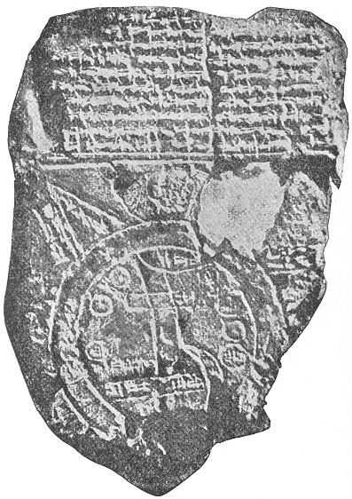
The Babylonian Map of the World is a diagrammatic labeled depiction of the known world from the perspective of Babylonia. The map is incised on a clay tablet, showing Babylon somewhat to the north of its center;[1] the clay tablet is damaged, and also contains a section of cuneiform text.
It is usually dated to the 6th century BC. It was discovered at Sippar, southern Iraq, 60 miles (97 km) north of Babylon on the east bank of the Euphrates River, and published in 1899.[2] The clay tablet resides at the British Museum (BM 92687).[3]
It is conjectured that the island locations, though possibly referring to real areas, may also represent a mythological interpretation of the world.[4]
Contents |
The map is circular with two outer defined circles. Cuneiform script labels all locations inside the circular map, as well as a few regions outside. The two outer circles represent water in between and is labelled as "'river' of 'bitter' water", the salt sea.[4]
Babylon is in the center of the map; parallel lines at the bottom seem to represent the southern marshes, and a curved line coming from the north, northeast appear to represent the Zagros Mountains.[4]
There are seven small interior circles at the perimeter areas within the circle, and they appear to represent seven cities.
Seven triangular sections on the external circle (water perimeter), represent named islands, but the damaged clay tablet has lost the three islands on the tablet's lower edge.
The three islands are named:
| 1. "Mountain" (Akkadian: šá-du-ú) 2. "City" (Akkadian: uru) 3. Urartu (Akkadian: ú-ra-áš-tu) 4. Assyria (Akkadian: kuraš+šurki) 5. Der (Akkadian: dēr) 6. ? 7. Swamp (Akkadian: ap-pa-ru) 8. Elam (Akkadian: šuša) 9. Canal (Akkadian: bit-qu) 10. Bit Yakin (Akkadian: bῑt-ia-᾿-ki-nu) |
11. "City" (Akkadian: uru) 12. Habban (Akkadian: ha-ab-ban) 13. Babylon (Akkadian: tin.tirki), divided by Euphrates 14 — 17. Ocean (salt water, Akkadian: idmar-ra-tum) 18 — 22. Mythological objects |